The Zadar archipelago
The small, often bare islands of northern Dalmatia – sometimes called the Zadar archipelago – see much less in the way of mass tourism than those in the south, and their rural nature provides them with bags of off-the-beaten-track allure. The northern end of the archipelago is full of semi-abandoned islands boasting beautiful bays and lush inland scenery, although few other than Silba possess significant tourist facilities. Silba’s near-neighbour Olib is worth considering as a day-trip if not necessarily a lengthy stay. Densely inhabited Ugljan, directly opposite Zadar, is almost a suburb of the city, and it is the long and barren Dugi otok, on the far side of Ugljan, that offers most in the way of stunning scenery, the beautiful Telašćica Bay – here, the archipelago’s most celebrated natural beauty spot.
Olib
With a catamaran operating daily between Silba and Zadar it’s possible to fit one of the other islands of the northern archipelago into a trip of one day or longer. One of the most rewarding of these is Olib, another small, car-free place offering unspoilt nature and an unhurried pace of life. In the twentieth century it was traditional for Olib families to emigrate to New Jersey, and you will encounter older locals speaking English with a pronounced North American drawl. A handful of local families offer accommodation, so it’s feasible to stay here if you plan in advance, although most people limit themselves to a day on the beach.
Olib’s main settlement is much more of a scattered rural village than a compact town, with long distances between family houses and only a church belfry to tell you where the centre might be. Beside the church is an impressively rugged medieval tower, built to provide refuge from raiding pirates. Beyond the church, a signed path leads to Slatinica Bay, some fifteen minutes’ walk between olive groves, where you will find a broad crescent of shingle and a shallow, sandy-floored bay.
Silba
For connoisseurs of soothingly unspoilt islands with no traffic and no hotels, kidney-shaped Silba is as perfect as they come. Not only are there no cars on the island, an unofficial ban on bicycles from mid-July to late August serves to preserve the island’s pedestrian pace. Strolling along maquis-lined country lanes in search of wild beaches is the only adrenaline sport you are likely to encounter.
Eight kilometres in length and only 1km wide at its narrowest point, Silba probably gets its name from the Latin word silva (wood) and is still covered with Mediterranean black oak, giving it an atmosphere quite different from that of its scrub-covered neighbours. The island’s one settlement, Silba Town, has an air of relaxed luxury, its palm-shaded houses and walled gardens serving as reminders of the island’s erstwhile commercial wealth, when sailing ships from Silba dominated the carrying trade between Dalmatia and Venice – only to be put out of business by the steam-powered vessels of the nineteenth century. During the 1970s Silba attracted a significant slice of both Croatia and Slovenia’s post-hippy, pre-punk intelligentsia, who camped wild on the southern part of the island. Nowadays a permanent population of about three hundred is swelled tenfold in summer, when independent travellers from all over Croatia and Slovenia come to enjoy the island’s uniquely relaxing rural atmosphere.
Silba Town
Silba Town straddles the island’s narrowest point, its streets sloping down towards two bays. The one on the western side of town contains the ferry dock and has some splendid sections of pebble beach. Rising over the middle of the town is the Marinić Tower, a lookout post with a spiral staircase running up the outside, supposedly built by a sea captain for the beautiful daughter of a woman who jilted him when a young man. Near the town church is an open-air sculpture park devoted to Marija Ujević Galetović (1933–), famous for her expressive human and half-human forms – notably the cat-headed woman who dominates the collection here.
The bay that marks the east of Silba Town is home to a harbour for small boats and yachts, and Šotorišće Beach, a broad, shallow bay with a sandy seafloor and a summer-only café-bar. Paths and gravel roads lead all over the island towards a multitude of other bays and beaches. One of the most popular is Dobre Vode, a majestic sweep of rock and pebble some fifty minutes’ walk south of the village.
Dugi otok
Some 43km long and at no point more than 4.5km wide, Dugi otok (Long Island) is the largest and arguably the most beautiful of the Zadar archipelago islands. With fewer than two thousand inhabitants, it boasts a wilder and more dramatic landscape than any of its neighbours, with sheer cliffs on its western side and a rugged, indented coastline.
Dugi otok’s main attraction is Telašćica Nature Park, which is best approached from the island’s main settlement, Sali, although the quiet villages and headlands of the northern part of the island are also worth a visit. It’s also a possible base from which to visit the Kornati archipelago, with boat captains in Sali offering trips, though the archipelago is more usually approached from Murter.
Telašćica Nature Park
It’s about 3km from Sali to the northern edge of Telašćica Bay, a 7km channel overlooked by smooth hills and indented with numerous smaller bays which run down to the tangle of islands at the northern end of the Kornati archipelago. The flora along the shoreline marks the transition from the green vegetation of the Zadar archipelago to the bare wilderness of the Kornati – banks of deep forest slope down towards the western shore of the bay, where maquis-covered offshore islands rise like grey-brown cones from the water – and the whole place has been designated a nature park.
From the car park it’s a twenty-minute walk to Uvala mira (Bay of Peace) at the park’s centre. There’s a bar and restaurant here, and a path that leads, after five minutes’ walk up a wooded hillside, to a stretch of ruddy clifftop looking out towards the open sea. Five minutes south of the restaurant lies Jezero mira, a saltwater lake cut off from the sea by a narrow barrier of rock. The excessively salty water of the lake is several degrees warmer than the sea in summer, and has therapeutic fango mud in its southeastern corner. Walk to the end of the lake to reach the rock barrier that separates it from the sea – it’s a popular spot for sunbathers and swimmers, many of whom have constructed towers and pyramids from the local pebbles and rocks to crate an eerie but compelling forest of stone.
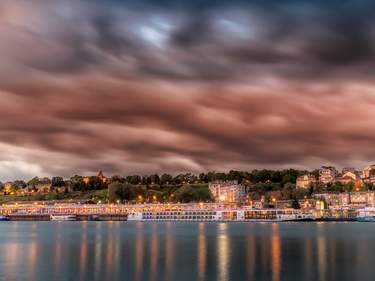
Top image: Famous Fosa harbor in Zadar aerial view, Dalmatia, Croatia © xbrchx/Shutterstock




_listing_1618090225076.jpeg)


_listing_1618089877244.jpeg)
